
Here is a set of photos from Curiosity Mars Rover:
 |
Gale Crater Vista
This is the first 360-degree panorama in color of the Gale Crater landing site taken by NASA's Curiosity rover. The panorama was made from thumbnail versions of images taken by the Mast Camera.
Image Credit: NASA/JPL-Caltech/MSSS
Image Credit: NASA/JPL-Caltech/MSSS
 |
Self Portrait on deck
This full-resolution self-portrait shows the deck of NASA's Curiosity rover from the rover's
Navigation cameras. The back of the rover can be seen at the top left of the image, and two of the rover's right side wheels can be seen on the left. Part of the pointy rim of Gale Crater forms the lighter color strip in the background. Bits of gravel, about 1 centimeter in size, are visible on the deck of the rover.
Seams between the images have been minimized, but a few are still visible. The wide field of view introduces some distortion at the edges of the mosaic.
The "augmented reality" or AR tag seen in the middle of the image can be used in the future with smart phones to obtain more information about the mission.
Image Credit: NASA/JPL-Caltech
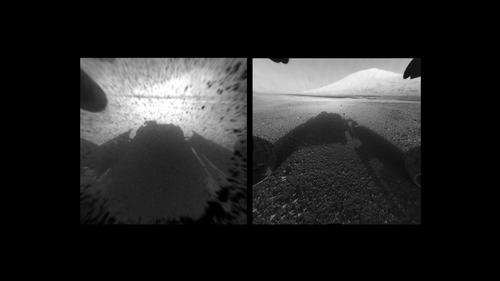
Clear Views on Mars
This image comparison shows a view through a Hazard-Avoidance camera on NASA's Curiosity rover before and after the clear dust cover was removed.
Both images were taken by a camera at the front of the rover. Mount Sharp, the mission's ultimate destination, looms ahead.
The view on the left, with the dust cover on, is one quarter of full resolution, while the view on the right is full resolution. Full- resolution images taken with the dust cover still on are not available at this time. The only other instrument on Curiosity with a dust cover is the Mars Hand Lens Imager (or MAHLI), located on the rover's arm. In this case, the dust cover is not removed but will be opened when needed.
This way, the instrument is protected from dust that may be generated from other tools on the rover's arm, in addition to wind-blown dust.
Image Credit: NASA/JPL-Caltech
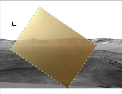 Curiosity's Landscape Portrait in Context
Curiosity's Landscape Portrait in Context
This picture of the Martian landing site of NASA's Curiosity rover puts a color view obtained by the rover in the context of a computer simulation derived from images acquired from orbiting spacecraft. The view looks north, showing a distant ridge that is the north wall and rim of Gale Crater.
The MAHLI image was taken while the camera's transparent dust cover was still on.
Curiosity's descent coated the cover with a thin film of dust.
The computer simulation is a digital elevation model that incorporates data from the High Resolution Imaging Science Experiment (HiRISE) and Context Camera on NASA's Mars Reconnaissance Orbiter and the High Resolution Stereo Camera on ESA's Mars Express.
The peak seen on the left-side of the MAHLI image is about 24 kilometers distant with a height of about 1,150 meters high. The box with arrows at the upper left indicates direction. The arrow pointing up is 'up' with respect to the gravity of Mars. The arrow pointing to the right is east. North would be an arrow pointing into the image (that is, the MAHLI view is toward the north).
The main purpose of Curiosity's MAHLI camera is to acquire close-up, high-resolution views of rocks and soil at the rover's Gale Crater field site. The camera is capable of focusing on any target at distances of about 2.1 centimeters to infinity. This means it can, as shown here, also obtain pictures of the Martian landscape.
Image Credit: NASA/JPL-Caltech/MSSS
Image and text credits: NASA/JPL-Caltech (click to obtain more images and in high resolution)


No comments:
Post a Comment